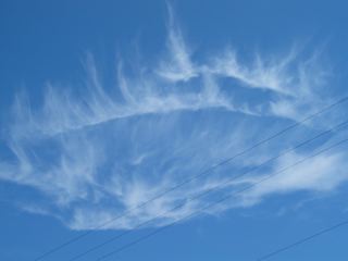
I have received a very interesting photo of a very unusual cloud seen over East Brady in Butler County, Pennsylvania. The photographer believes this picture was taken on July 6, 2012. What I learned is that this odd cloud was first observed over the river in May of 2012. It has reportedly been seen several times since then, and appears in the same part of the sky over the Allegheny River near East Brady. It only seems to appear on clear days and is a large cloud formation that stays intact for an hour to an hour and a half. It is also estimated that the tops of the cloud formation are at about 15,000 feet and the base is around 7, 000 feet.
There are no factories or other heat sources in the immediate vicinity of where the cloud formation has been observed. The witness described to me that when this cloud begins to form it is, “like heat sucking moisture out of the air and moving over it.” It then creates the flame-like effect. The man told me that the next time he sees it, he will video tape it so it can be studied in more detail.
I asked Richard Kane, Chief Meteorologist at the National Weather Service Office in Pittsburgh for his opinion of the cloud photo. This is his report.
It is very strange looking indeed. I do think it is something called a “Distrail” (short for dissipation trail). Sort of the opposite of a contrail. If the humidity structure/content of the upper atmosphere is right, you will get condensation trails (contrails) from aircraft. The contrails often tend to spread (sort cloud seeding from the exhaust). However in the right circumstances once the cloud seeding process starts, another aircraft exhaust coming through the same area can actually accelerate or dissipate the process and you can get trails through cloud decks or sometimes even holes through the clouds. It all depends on the humidity structure and sometimes the upper level wind field and of course, the altitude of the aircraft. Distrials are more common with mid-deck clouds…alto-stratus or alto-cumulus (where more super-cooled water exists). These pictures are with cirrus clouds(ice crystals).
There’s a physical process in the atmosphere called (Bergeron-Findeison process) which states that the vapor pressure (or saturation vapor pressure) around ice crystals is lower than than over liquid water. So, when liquid water is introduced (jet exhaust) in the right environment, the ice crystals grow at the expense of the water vapor and you can get these holes or more often the formation known as Mare’s Tails with ice crystals growing and the water vapor decreasing and going right to the ice phase. Contrails are very common, however, distrails are much less common and I think the general type of distrail is the linear or path that is hollowed out in the cloud deck by a jet exhaust. The circular or “hole” type is much less common.
If you google “distrail” and images, you’ll see examples of the different types of distrails. I guess bottom line, it is a great picture but I also think it can be physically explained. Let me know if you have any questions.
P.S. Took a look at the jet routes and you can see from the attachment that there are numerous high level jet routes across western PA.
Jim Brown, a research associate of mine, did a photo analytical study of the picture and has forwarded this report.
As I stated earlier I also tend to think this is a cloud formation as opposed to anything directly or intentionally created. The distrail idea is quite plausible based on the report. I would recommend that the next time the witness observes this phenomena he take multiple pictures not just of the formation but all other clouds in the sky at the time and also note their position relative to the phenomena. This could serve to resolve the issue especially if there was evidence of a contrail or partial contrail aligned with the phenomena.
I do have a couple questions though that I would like to see addressed. I am under the impression that this phenomena was seen numerous times over the same area. If so, and if it is relatively rare as is the impression given by the report, what accounts for this repeated sighting over the same area? Also does anything on the surface below the formation produce any source of heat where convection might carry this heat aloft and possibly cause the repeated formation to be seen? I do agree the clouds are cirrus and probably formed by water vapor as stated in the report. My questions deal more with the cause they would be seen so often over the same area. Thus it is not the cloud itself, rather the cause which is the question to be resolved.
If you have seen a cloud formation like this in your area please contact me.

